- Home
- Geotermal Activities
- SEISMIC EXPLORATION
SEISMIC EXPLORATION
Seismic searches are a form of geophysical research that aims to measure the properties of the Earth through physics principles such as magnetic, electrical, gravitational, thermal and elastic theories.
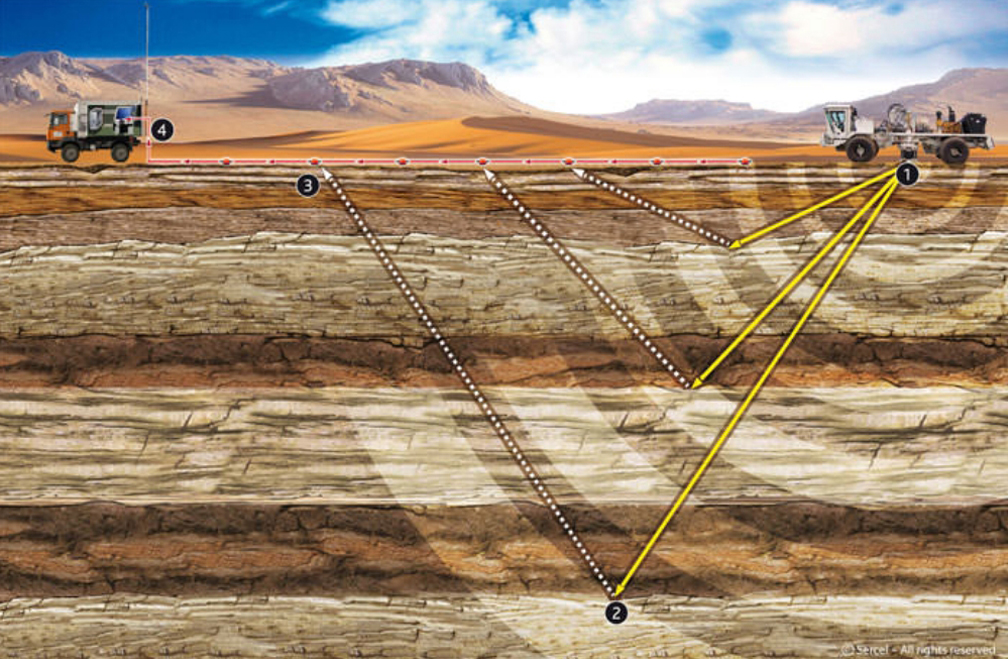
Seismic research methods emerge from the radiation of seismic waves (signals) produced by any source. As seismic waves travel underground, they are reflected, refracted or scattered during changes in the environment that will create an acoustic impedance difference, and eventually return to the earth's surface. When they return to the Earth’s surface, they are detected by sensors called geophones and recorded in a seismic recording unit. With the principle of wave radiation, the center of the Earth can be examined, as well as the examination of a very small area of the Earth. It can be used to determine the parameters in the calculations of all kinds of engineering structures to be built on the ground, as well as to determine the richness of the underground.

The basic principle in seismic searches is that the amplitudes of the waves emitted from the energy source and their arrivals at the receivers against time are recorded as seismic reflection shooting points by a network of highly sensitive sensors placed on the surface. 2D and 3D imaging, made by analyzing these recorded data by means of special software on powerful computers, are used to help fully determine the existence of natural resources (thermal reserves) and to characterize their potential.
Seismic sections obtained from seismic explorations have higher sensitivity and discrimination power than those obtained from all other geophysical methods. For this reason, seismic searches have become the most common method in the world, using the most money, time and geophysicist sources. The healthiest and most accurate information about the structural condition and stratigraphy (layer structure) of the underground is obtained from a drilled well. However, the information obtained from the well is for a single point on the map and only in vertical direction. In order to carry this information from a single point to the entire map, the use of seismic method is a must.

Energy Holding Geophysical Services Department (EHGED) can collect data using seismic equipment, which is a complete system with synchronizers and controllers, using wired and wireless equipment and drones, which require less manpower than old and expensive conventional applications. With these collected data, 2D and 3D underground modeling can be done. 3D analyses are completed in a short time using powerful computer systems with high core quantities.
EHGED uses SERCEL equipment, a unique system for wireless seismic searches. SERCEL is undoubtedly the most advanced wireless system with its state of the art technology and full compatibility with all other EHGED equipment. Whether for data storage or real-time data transmission, wireless QC and data collection capabilities offer an unprecedented level of flexibility and quality control.
Our list of advanced technology SERCEL equipment used in seismic exploration activities:
- 428XL - Central Units and Server
- 2200 Channel Sensors
- 428XL and UNITE – Peripheral Equipment
- ÜNİTE - Acquisition Units
- ÜNİTE - Software pack
The combined use of MT and seismic methods in the detection of geothermal resources is the most effective method accepted in the world.


